The South African Astronomical Observatory celebrates 200 years of its existence
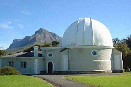
The South African Astronomical Observatory

On 20 October 1820, the Royal Observatory Cape of Good Hope, which became known as the South African Astronomical Observatory (SAAO) was founded. It is the oldest scientific institution in the country. The institution was formally controlled by the British Admiralty. Its purpose was to observe the southern skies and to provide a time service for ships passing Cape Town harbour. The Observatory is known for its history and its immense contribution to positional astronomy in the southern hemisphere. Besides, its buildings are regarded for their special architectural significance.

Celebrating 200 years of the South African Astronomical Observatory by Karel van der Vyver (Daily Maverick), 16 October 2020
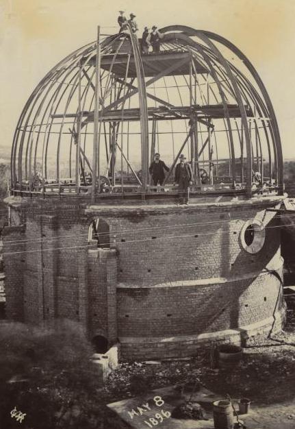
Construction of the McClean telescope 1896

Perched on the outskirts of Observatory in Cape Town, just above the Black River, stands the South African Astronomical Observatory; initially known as the Royal Observatory, Cape of Good Hope, it has multiple telescopes, a museum, a mechanical workshop that can “build, maintain and support the various instruments used on telescopes in Sutherland”, and a library.

Now, the observatory is turning 200, and on the day of our visit, the place is bustling with people busy sanding the inside of the building, painting walls, and preparing the observatory ahead of the celebrations.

Language

Delgoa Bay Now Known as Maputo Bay, Mozambique

Delgoa Bay is a Bay on the South East coast of Mozambique, East Africa, near the South African border. Discovered by António do Campo, a member of Vasco da Gama’s expedition (1502), it was first explored by Lorenzo Marques, a Portuguese trader, in 1544. It was important as an outlet for ivory and slaves, as a way station for Indian Ocean trade, and as an avenue of approach to South African diamond fields and goldfields. Ownership was contested by the Portuguese, Dutch, English, and Boers until by arbitration (1875) it was awarded to Portugal.
Geolocation
32° 26' 38.4", -26° 4' 22.8"
References
https://www.britannica.com/place/Delagoa-Bay
Further Reading
ttps://www.cambridge.org/core/books/history-and-ethnography-of-africa-south-of-the-zambesi-from-the-settlement-of-the-portuguese-at-sofala-in-september-1505-to-the-conquest-of-the-cape-colony-by-the-british-in-september-1795/occupation-of-delagoa-bay-by-the-dutch/9F9FE9048B61AEE4F7714E77863655EA

South African Royal Astronomical Observatory, Cape Town

The Royal Observatory occupies a small wooded Hill about 6 km East of central Cape Town, within a Conservation Area known as; the Two Rivers Urban Park. Its location was originally chosen to be within view of the Table Bay, the anchorage in front of the City, to permit the visual signaling of time to visiting ships, because of the treacherous Sea, hence the name: 'Cape of Storms'. The Greek Revival Main Building of 1825-8 still dominates the Hill and faces a lawn to the South which forms an axis along which are many smaller edifices such as domes and dwelling houses, most dating from the Victorian period and forming a pleasant coherent whole. The only large modern building is inconspicuously located at the back (North) of the Main Building towards the Northern end of the Property.
Geolocation
18° 28' 26.4", -33° 56' 2.4"
References
https://www.saao.ac.za/about/history/ https://www3.astronomicalheritage.net/index.php/show-entity?identity=52&idsubentity=1
Further Reading
https://www.dailymaverick.co.za/article/2020-10-16-200-years-of-the-south-african-astronomical-observatory/ https://www.saao.ac.za/about/history/ https://www.nature.com/articles/138320b0

Dal Josafat, Paarl

The name is of biblical origin, also spelled: "Dal Josafat or Dal Josaphat".

Dal Josafat has an interesting and varied selection of Buildings dating from the 18th Century. This beautiful Area along the road from Paarl to Wellington was settled for the most part by Huguenots. The original Farm of Dal Josafat, now named: "Roggeland", is the oldest in the Area. The farmlands were granted to Peter Buck of Lübeck in 1692, but it was Andries Bernardus du Toit who, in 1780, built the recently restored H-shaped gabled Houses.

'Kleinbosch' was built in 1792 by Guillaume du Toit, on land granted to his grandfather, Francois, one hundred Years before. Kleinbosch has close connections with the Afrikaans language and its origins. It was the birthplace of Stephanus Jacobus du Toit who later, when he became a minister of religion and a journalist, founded and led the Afrikaans Language Movement, 'Die Genootskap van Regte Afrikaners'. Stephanus' elder brother, Daniel Francois, later became editor of the Movement's journal, 'Die Afrikaanse Patriot'. Another member of the group to be connected with Kleinbosch was Petrus Jacobus Malherbe, who bought the property in 1880. A year later his son Daniel Francois was born there, and grew up to be a prominent writer and leader in Afrikaans cultural matters. The Farm School where several of these eminent men were educated is situated at Kleinbosch, as is the Huguenot Cemetery.

Geolocation
-33° 41' 56.4", 19° 25.2"
References
https://sahris.sahra.org.za/node/30897 https://sahris.sahra.org.za/node/30733 Picton-Seymour Désirée, 1989. Historical Buildings in South Africa. Cape Town: Struikhof Publishers. p, 52. http://www.kznhealth.gov.za/addingtonhospital.htm

Mabel Palmer

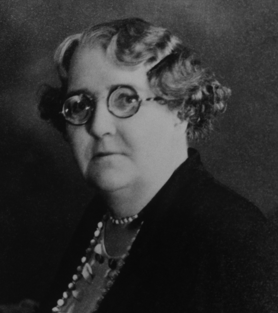
Dr Mabel Palmer (nee Mabel Atkinson) was born on 22 May 1876 near Stocksfield in Northumberland, England. Her father, J.B. Atkinson, was a mine inspector, and her mother, Jane Atkinson, a militant suffragette. Her mother’s activism most likely had an impact on young Palmer, who would later become a prominent feminist campaigner.
Wagendrift Nature Reserve and Dam, Escourt

Wagendrift Dam and Moor Park Nature Reserve is situated just off the N3 highway, near Estcourt. The Reserve is roughly 980 square Kilometers, in extent and includes a popular picnic and fishing spot. An Iron Age site dating back to AD 1300 is found on Makhabeni Hill overlooking; Moor Park and is listed as the first known Iron-Age Settlement in Southern Africa. On the Southern side of the Dam, there are large fossil beds with many fossilised trees lying exposed at ground level. As its name suggests, Wagendrift Nature Reserve is so called after a Drift through the Bushman's River favoured by transport wagons on route to Witwatersrand from Port Natal, where gold fields attracted many people at the time. On Makhabeni Hill, overlooking Moor Park, which is included in the parameters of Wagendrift Nature Reserve, one has a bird's eye view of an Iron Age site dating back to AD 1300, one of the oldest in KwaZulu-Natal, where there are large fossil beds lying exposed, as well as fossilised trees - anyone even vaguely interested in archaeology will find this a hidden treasure. Wagendrift Dam is a picturesque dam named after a drift through the Bushman's River used by transport wagons on their to the Witwatersrand goldfields. The Dam is surrounded by the Wagendrift Reserve and is a protected Area! Boating and fishing are the main activities. There is a 3 km self-guided Trail along the Bushman's River. Found here are; Fish Eagle and Black Eagle, which nest in the reserve. Species of fish include bluegill, bass, carp, eel and the occasional trout.
Geolocation
29° 49' 55.2", -29° 3' 32.4"
References
http://www.kznwildlife.com/Wagendrift.html https://www.sa-venues.com/game-reserves/wagendrift.php https://www.safarinow.com/destinations/estcourt/damsvleis/wagendrift-dam.aspx
Further Reading
http://www.kznwildlife.com/Wagendrift.html https://www.nationalgeographic.org/encyclopedia/continental-drift/

Imbali Township, Pietermaritzburg

“Imbali” is the IsiZulu word for “Flower”. Imbali Township was established in 1958 and built in the mid-1960s to settle the City workers and employment seekers away from the City of Pietermaritzburg. In 1964 the Department of Bantu Affairs in partnership with Pietermaritzburg Co-operation took over the control of the Area. Blacks that were affected by the Group Areas Act, were the first residents of what came to be known as Imbali Bantu Township. It is Pietermaritzburg’s biggest and one of the oldest Townships and is located 15km West of the City. The FJ Sithole Road is the main road that enables the citizens and the tourists to get the gist of Imbali Township, as it connects main streets and navigates through the remarkable landmarks! The streets are predominantly named after wildlife. The Township is blessed with the abundance of primary Schools, high Schools and one tertiary College; Clinics and Police Stations. An art Library is to be unveiled in the near future, that will be well-looked after by the Imbali Township Community! It is part of Msunduzi Local Municipality that forms part of uMgungundlovu District Municipality. The main modes of transport for people are the minibus Taxis and Sedans. Enthusiastic shoppers can indulge in a variety of shopping experiences from the Mall and Shopping Centres, that are located in Imbali Unit 3 as well the traditional Spaza Shops, that are widespread across the Townships. The Manaye Hall in Imbali is a Monumental Landmark as a venue; for the All-In-Africa Conference that was organised in March 1961. It is in the Manaye Hall where Madiba addressed the gathering and made a call for the philosophy of “One Man, One Vote” which is now enjoyed by many generations. Madiba also gave life to the mantra “Amandla” which loosely translates to “Power To The People”. The Historic Manaye Hall is set to be turned into a Museum and Heritage Site. Imbali Township will recreate its History and will hold annual awards called Qhakaza Awards to celebrate and honour the impeccable achievements and excellence from its ordinary citizens for generations to come!
Geolocation
30° 20' 52.8", -29° 39' 3.6"
References
https://imbalitownship.com/ https://capitalnewspapers.co.za/104475/historic-hall-turned-tourist-attraction
Further Reading
https://northernnatalnews.co.za/191252/dj-spencer-got-eye-prize https://imbalitownship.com/our-mothers-and-daughters-izimbali-zethu