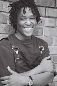
Sandile Dikeni

Sandile Dikeni was born in Victoria West, Northern Cape in 1966. He began writing poetry while in detention for his anti-apartheid activism in the 1980s. He became sought after for his performances and rose to prominence in the Western Cape as a major voice against oppression. Dikeni attended the University of the Western Cape (UWC), obtained a diploma in journalism through Peninsula Technikon. He was arts editor of the Cape Times, editor of Die Suid-Afrikaan and political editor of This Day South Africa.

Kenneth Stainbank Nature Reserve

The Kenneth Stainbank Nature Reserve lies just next to Yellowwood Park in Durban, an extension of The Durban Metropolitan Open Space System green lung in the south western parts of Yellowwood Park. Kenneth Stainbank Nature Reserve is held by locals as not only a wonderful space in which to do walks along trails that give you up to four hours' worth of walking, but also great for birding and picnics. The 253 hectare Kenneth Stainbank Nature Reserve is regarded as one of the finest coastal / river forests and bush clump / grassland mosaic areas remaining in the greater Durban area. The land was a bequest from a man named Kenneth Stainbank, hence the name, and aside from the wonderful plant life, you also get to see zebra, bushbuck, reedbuck, impala, blue, red and grey duiker, vervet monkeys, mongoose, bushbabies and dassies or rock hyrax. There are even night drives that one can arrange. Over and above the 13 kilometres of nature walks there is also a 10 kilometre mountain bike trail, regarded as moderately challenging – in other words, a good weekend ride that won't see you exhausted, and Durban's mountain bikers enjoy the reserve as a refuge. A handicapped trail leads into the forest from the car park, and although the variety of birds along this trail might not be as good as deeper in the reserve, you can still hope to spot the grey cuckoo shrike, tambourine dove and the white-eared barbet. The dam area is where you'll find more water birds, including the red-chested fluff tail, whilst a climb into the forest area, where it is quieter and you need a little more patience, will give you access to the: olive woodpecker, lemon dove and yellow-bellied greenbul. The reserve is managed by Ezemvelo KZN Wildlife and there is no accommodation within the reserve, but see Yellowwood Park accommodation for the closest options. Daily from 06h00 to 18h00.
Geolocation
30° 56' 31.92", -29° 54' 46.8"
References
https://www.sa-venues.com/game-reserves/kenneth-stainbank.php
Further Reading
https://kzntrailrunning.co.za/races/kenneth-stainbank-castle-trail/ https://www.tripadvisor.co.za/Attraction_Review-g312595-d591479-Reviews-Kenneth_Stainbank_Nature_Reserve-Durban_KwaZulu_Natal.html http://www.kznwildlife.com/ https://www.portfolio-property.com/article/view/id/403

Coligny, North West Province

The town lies 193 km due west of Johannesburg on the road to Lichtenburg, which is 29 km away. Originally named 'Treurfontein' (well of sadness), the name was changed to honour Admiral Gaspard de Coligny, a staunch French Huguenot who was killed in the Massacre of Saint Bartholomew’s Day (24 August 1572) in Paris.

At first sight, Coligny gives the impression of being just another dusty, windswept Village – forgotten in the mists of time and bypassed by modern life. In a way it has retained its “old world” character, but it hides a wealth of History and fascinating character. With the last sitting of the parliament of the old Transvaal Republic, before the Union of South Africa was formed in 1910, General Koos de la Rey, representing Lichtenburg, managed to get his proposal accepted for the railway line to be extended from Welverdiend in the East through Coligny, to Lichtenburg and South to Delareyville.

A Year later, the plumes of the first locomotive blew over the area, signalling the birth of a Town. Even though it was built on the Farm Rietvlei, it was named: 'Treurfontein'. This was to distinguish it from the Rietvlei station near Heidelberg, in Gauteng. The station is still the heartbeat of the Town, with lines spreading to all four points of the compass. In 1910, all that could be seen among the waving maize crops, was a lonely building, housing a school with two teachers and 37 students. Soon after the establishing of the station, a shop built from corrugated iron was put up by the brothers; 'Mangelsdorf'. Sixteen years later, the NG Church was completed. It was later extended as the congregation grew. Originally it was named: 'the Welgemoed-Congregation'. The editor of the newspaper “The Western”, H. J. Malan, however urged them to change the name to 'Coligny', after the famous Huguenot leader, Gaspard de Coligne. He was murdered on August 24, 1572 during the Bartholomew Night, or Bloody Night, when 10 000 protestants were murdered by the Roman Catholic monarch. Many Huguenots, later fled to South Africa. After this name change, authorities were urged to also change the name or the station to Coligne.

In 1922 it was declared a Township. A Town council was constituted in 1929. The Cemetery lies just off the road to Lichtenburg, about two kilometers out of Town. A Monument to the Town’s eponym, stands in the hall of the local School. Unfortunately all the blockhouses have been demolished and the graves desecrated and unkempt, with cattle grazing freely! (The British war Memorial has grazing among it as well).

Even though blood also flowed in this Town during the 1914 Rebellion, there seems to be little evidence of it. The Silo in the middle of Town and next to the Station is the first vertical Silo to be built in the North West Province and is seen as a symbol of one of the richest maize growing regions in South Africa.

Geolocation
-26° 19' 51.6", 26° 16' 1.2"
References
http://www.tourismnorthwest.co.za/coligny/#tab=tab-1

Clairwood Hospital, Durban

Clairwood Hospital, a public hospital operated by the KwaZulu Natal Health Department, is situated in Durban South, KwaZulu Natal. Hospital services include a Staff Wellness Clinic, Ante Natal Clinic and School Health Services. Clairwood Hospital was opened on 01 May 1956. It was originally an army barracks and later converted into a hospital. The hospital is situated in Mobeni, a southern suburb of Durban. The community served by the hospital are from the following areas: Lamontville; Mobeni; Merebank; Woodlands; Montclair; Woodhaven; Yellowwood Park and Clairwood. Clairwood hospital is a provincial hospital, therefore services are free to pregnant and breastfeeding women as well as children under the age of six years old. Other citizens are charged according to a sliding scale depending on their income. Clairwood is a specialized rehabilitation and convalescent hospital. They strive towards providing optimal health care for all persons, enable them to increase, control and improve their status. This is insured by being cost effective, efficient, convalescent and rehabilitative service in consultation with all stakeholders, dedicated to health promotion based on the primary health care approach through the district health system. Visiting Hours Monday to Friday; 14h00pm - 15h00 and 18h00 - 19h00 Weekend And Public holiday; 13h00pm - 15h00 and 18h00 - 19h00
Geolocation
30° 57' 21.6", -29° 56' 6"
References
http://www.kznhealth.gov.za/clairwoodhospital.htm https://www.travelground.com/attractions/clairwood-hospital
Further Reading
https://www.timeslive.co.za/news/south-africa/2018-06-14-eight-alarm-bells-at-south-african-state-hospitals/

Sannieshof, North West Province

Sannieshof is a small train stop and farming town in the middle of the North West Province’s maize farming belt, it lies surrounded by the four towns of Potchefstroom, Klerksdorp, Mahikengand Vryburg. The a vast rural area called: the ‘Stellaland' (Star Land) or Platteland (Flat Land), and is known for its massive bank of grain silos and plant nurseries. It started as a post office to serve the farms in the district and was named in honour of the first postmaster, John Voorendijk's wife Sannie. Sannieshof is very small community, but well worth a visit if you are driving through the the North West on the N14, to enjoy the local hospitality, food and a few other delightful little surprises, in this small close knit town, before visiting the Barberspan Bird Sanctuary only 30km away, between Sannieshof and Delareyville. Sannieshof is 70km south-west of Coligny on the N14. Look out for huge grain silos!
Geolocation
25° 46' 55.2", -26° 32' 56.4"
References
https://showme.co.za/south-africa/north-west/central-district/sannieshof/sannieshof-central-district-north-west-province/ https://pathfinda.com/en/sannieshof
Further Reading
https://www.jbaynews.com/sannieshof-municipal-services-come-to-a-complete-standstill/ https://www.geni.com/people/Jan-Voorendyk/6000000014726280852

Yellowwood Park, Durban

The first thing that strikes you about the leafy garden suburb of Yellowwood Park, just 14 kilometers from Durban, is that the majority of the roads are named after birds - Lark Lane, Kestrell Road, Wren Way - and that, as these may well indicate, this is a birdwatcher’s paradise, particularly with the Kenneth Stainbank Reserve well within its parameters. Bordering on Chatsworth and south west of Durban, Yellowwood Park has a real sense of village life. The Community Hall or civic centre is a beautiful Cape Dutch building that is for hire for weddings and various other occasions, and the suburb is almost tranquil with its park-like surrounds. The Centre for Rehabilitation of Wildlife (CROW), based in Yellowwood Park and on many a junior school’s list of educational places to visit, cares for injured and orphaned wild animals and birds - most of their injuries due to human negligence. Not to mention the Kenneth Stainbank Nature Reserve, one of the most beautiful areas of coastal ravine forest and bush clump grassland mosaic still remaining in the greater Durban area, has some wonderful trails, picnic sites and the chance to see local birds, zebra and buck, some of them around the small dam just down from the car park.
Geolocation
30° 55' 8.4", -29° 54' 46.8"
References
https://www.sa-venues.com/attractionskzn/yellowwood-park.php
Further Reading
https://www.wheretostay.co.za/town/yellowwood-park/accommodation

Barberspan Bird Sanctuary

The Barberspan Bird Sanctuary is a huge 2000 ha body of water located between Delareyville and Sannieshof. The Reserve is a pioneer in ornithological research. Bird Life South Africa has declared it an important national birding site. Given then that it is also a RAMSAR Convention-accredited wetland of international importance for migratory birds and waterfowl, it is well worth a visit. The pan is the focal point of a provincial nature reserve and is fed by the Harts River. Barberspan's terrain is flat and grassy and sometimes seems rather bleak, but its rich and varied birdlife makes it an ideal study area. The pans, which are fed intermittently by the Harts River, are an important drought refuge for waterfowl which arrive in numbers from the surrounding pans to wait out the dry season. Barberspan and the adjacent Leeupan, connected by a shallow channel, are over 4 000 ha in extent comprising shallow alkaline waters ideally suited to the many species which favour such conditions. The area around Barberspan is undulating grassland and agricultural land, leaving the pans largely undisturbed. Certain areas on the pans are designated for anglers to enjoy excellent fishing opportunities for carp, barbel and yellowfish. Boating opportunities are offered and a number of photographers hides are available. Bird-watching from a canoe (bring your own) is rewarding. The reserve is flat and its grasslands support black wildebeest, springbok, blesbok, zebra and ostrich as well as smaller mammals including jackal, porcupine, yellow mongoose and ground squirrel. Summer is the best time to visit the reserve. The Barberspan Bird Sanctuary is probably unique in South Africa, for the sheer numbers and variety of birds to be seen on the pans. 365 species have been recorded, including a number of rare migrants, making Barberspan an essential stopover for all birders. Pelicans and flamingo, grebes, terns, herons, cranes, ibis and bitterns to mention just a few. All but one of the South African duck species have been recorded at the pans. Directions The reserve is open daily from 6 a.m. to 6 p.m. Barberspan is signposted from the N14 which links the small towns of Delareyville and Sannieshof.
Geolocation
25° 30' 10.8", -26° 37' 51.6"
References
https://www.places.co.za/html/barberspan_nr.html https://ho.org.za/parks/barberspan-bird-sanctuary/

Delareyville, North West

This Historical Town in the vast North West Province has a rich History that is deeply rooted in South African Culture.

It was founded in 1913, after the tragedies of the Anglo-Boer War, and was named after General Koos De la Rey. Today, it continues to be an important hub for farming and for the production of salt. The little Town of Delareyville and the surrounding Farms are occupied by fewer than: 2 000 permanent residents. The Area is an integral part of South African Agriculture. Here, sorghum, groundnuts, maize and sunflowers are the main crops. The farming of cattle and sheep is also common here.

The community’s farming methods are progressive which keep Delareyville, among those in the forefront of the South African Agriculture Industry. The salt pans, with their iconic pink colouration, are a hotspot for flamingos. These elegant pink birds gather in their hordes to feed on the salty little snacks in the pan’s waters.

Delareyville boasts a number of tourist attractions in and around the Town Centre. These include: • The Dutch Reformed Church – this is a National Monument, perched on the main street. • A round of golf at the Delareyville Golf Club. • Facilities for playing tennis, bowls, and netball. • Barberspan Nature Reserve – just 15 kilometers from the Town. 'This is a stunning spot to enjoy excellent bird-watching and fishing, as well as boating'. • The Henk Joubert Game Reserve – home to a number of antelope species (including kudu and springbok), as well as ostrich and zebra. • The Rooiwal Monument – (this is dedicated to some of the burghers who died during the Anglo-Boer War.) • Gestoptefontein – an old house with plenty of Historical import. • An Olympic-sized swimming pool for visitors that want to keep active (and cool). Delareyville is less than 100 kilometers South-West of Lichtenburg and just over 80 kilometers North-East of Vryburg. It takes about 3.5 hours by car from Johannesburg and its International Airport, to this Agricultural hub.

Geolocation
-26° 41' 16.8", 25° 26' 2.4"
References
https://www.sa-venues.com/attractionsnwp/delareyville.php google
Further Reading
https://www.helicopterscharter.com/charter/from-to/helipad.php?icao=FADL https://www.thesouthafrican.com/news/ottosdal-protests-north-west-municipality-financial-debt/ https://www.jacarandafm.com/news/news/north-west-learner-killed-group-armed-attackers/ https://www.farmersweekly.co.za/crops/field-crops/cotton-can-be-more-profitable-than-maize/