Dutywa, Eastern Cape

The Town was founded in 1858 as a Military Fort after a dispute between a Natal Colony raiding party and local people. It is named after the Dutywa River, a tributary of the Mbhashe River.The name means "place of disorder" in the Xhosa language. Its spelling was officially changed from "Idutywa" to "Dutywa" on 16 July 2004. The Settlement was laid out in 1884 and was made a municipality in 1913, formerly part of the Transkei bantustan. It is the birthplace of Thabo Mbeki, who became President of South Africa in 1999. It is 35 kilometres north of Gcuwa (formerly known as Butterworth) on the N2 road. Dutywa is the seat of the Mbhashe Municipality in the Amatole District. Dutywa is an inland Town and an economic center to the nearest coastal town Willowvale Gatyane. The economic contributions to this town mostly come from the agriculture, education and the rapidly developing infrastructure. This town recently finished developing a shopping complex in 2017, and has good recreational areas including sporting centers. Da Village is a heritage/bar which is oriented for fun! A Center where prominent artists with the likes of Zahara who is a South African musician among others and radio presenters come to mingle. Mida School is a Combined School schools based in Dutywa, Eastern Cape, South Africa.
Geolocation
28° 19' 12", -32° 5' 56.4"
References
https://web.facebook.com/pages/Idutywa-School-Of-Excellence/111869302263135?_rdc=1&_rdr https://www.schools4sa.co.za/school-profile/mida-school/ http://www.distancecalculator.co.za/data/Distance-Between-East-London-and-Idutywa_475.html https://web.facebook.com/pages/-Da-Village-kwa-Ace/139346969475929?_rdc=1&_rdr

Vergelegen Wine Estate Owner Samuel Kerr Dies

Vergelegen Wine Estate

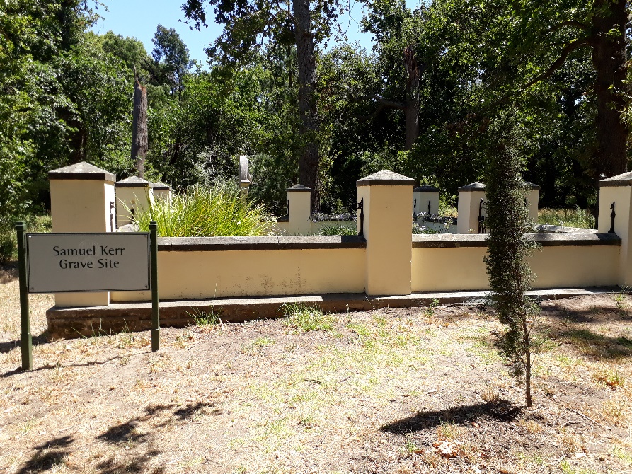
Samuel Kerr,an Irishman, wastheowner of the Vergelegen Wine Estate, Somerset West from 1901-1917. He acquired the estate on 29 March 1901 at a price of £11,404. He was also the owner of sixsurrounding properties since 1899 before acquiring Vergelegen. His wife and eight children lived with him in the Old Homestead at the estate. The Kerr family used to host several parties and picnics at the estate and enjoyed the outdoors. They also spent time renovating the homestead.

The Old Slave Tree Memorial

The Old Slave Tree Memorial is located in Spin Street, Cape Town. It was an old fir tree that was cut down in 1916. The site is now an octagonal memorial erected on a traffic island in remembrance of the very large number of slaves that were said to be sold under the tree. The words “On this spot stood the old slave tree” is inscribed on the plaque.  Most of the slaves, who were sold under the tree, were brought to the Cape from Africa and Asia. The slave tree is located in close proximity to the Slave Lodge, which housed many of the slaves and too operates as a slave memorial now. The slave tree also functioned as a gathering for slaves who were not allowed to enter churches. In 1951, the last remnants of the tree were removed as the stump of the tree was destroyed in order to widen the street.  In 2014, the Old Slave Tree Memorial was highlighted during the World Design Capital event in Cape Town.
Geolocation
18° 25' 14.88", 33° 55' 28.56"
References

Galt, R. (2017).  Heritage trees of Cape Town: beacons of local history & culture. Available online:
www.currentconservation.org/heritage-trees-of-cape-town-beacons-of-local-history-culture/. Accessed [20/01/2020].

Iziko Social History Centre. (2020). Museums. Available online: dev.iziko.org.za.dedi6.cpt3.host-h.net/museums/iziko-social-history-centre. Accessed [20/01/2020].

Manjoo, S. Classrooms in the Shade. Johannesburg: STE Publishers, 2008.

Where to Stay. (2020). The Old Slave Tree Memorial. Available online: www.wheretostay.co.za/topic/6161-the-old-slave-tree-memorial. Accessed [20/01/2020].
 

Slave Church Museum

The South African Missionary Meeting House/ Sendinggestig Museum (short for the Slave Church Museum) was built between 1802 and 1804. It was founded by the African Missionary Society in 1799. The church is located in Long Street, Cape Town and is South Africa’s oldest indigenous mission church that still exists in its original structure. It is also the first official slave church in South Africa. The church was predominantly used as a space to educate slaves and those identified as non-Christians in the Cape- hence the name of the establishment. In 1802, around 280 slaves were taught literacy and religion at the church. The slaves belonging to the Dutch East India Company (VOC) in the Slave Lodge mostly gained access to the church and went on to be baptised and confirmed making them full members of the congregation. Slaves who did not attend the church were often taught in their homes or at the harbour by church goers throughout the 18th century. By the 1770s, slaves who were baptised could no longer be sold. This ruling however was not always adhered to.

The church was also used for meetings held between church directors and members as well as to preach. Sundays, in particular, were used for divine services. By 1971 the church was sold due to the poor state of the building and a new church was established in Belhar. However, in 1977 it attained heritage status and was restored by the Cape Provincial Administration. The museum is open daily and does not require anentrance fee.

The church depicts the history of mission work undertaken by South Africans. It also displays church furniture and objects, original documents, audio and visual files. The front church benches feature the names of the first eight slaves baptised at the church, and the wooden floor has a representation of stars to commemorate the abolition of slavery in 1834 in the Cape. The main exhibition consists of ten illuminated panels, which showcases the church’s history, missionary work and information about the church community. The exhibition was created by the University of Cape Town students and researchers Siona O’Connell and Nadia Kamies.

Geolocation
18° 25' 13.8324", 33° 55' 16.806"
References

Cape Town History. (2019). Sending Gestig Church. Available online: capetownhistory.com/?page_id=455. Accessed [17/01/2020].

Cornell, C. Slaves at the Cape- a Guidebook for Beginners Researchers.Cape Town: Hansa Reproprint, 2005
Daniels, N. (2018). Exhibition honours Slave Church on 219th anniversary. Available online: www.iol.co.za/capetimes/news/exhibition-honours-slave-church-on-219th-anniversary-14600404. Accessed [17/01/2020].

Duncan, P & Proust, A. Hidden Cape Town. Cape Town: Stuik Lifestyle, 2013

Middledrift, Eastern Cape

Distance between East London and Middledrift. It takes 1 hours, 52 minutes to travel from East London to Middledrift. It takes 1 hours, 52 minutes to travel from East London to Middledrift. Approximate driving distance between East London and Middledrift is 94 kms or 58.4 miles or 50.8 nautical miles. It is situated in Raymond Mhlaba Municipality in Amathole District in an area that was formerly part of the Ciskei. It has a population of 2 140 (2011). It has a traditional Xhosa Chief; Chief Sibulele Mhlambiso, Chief of AmaNgqika-Mbo Traditional Council, Middledrift.
Geolocation
26° 58' 33.6", -32° 48' 10.8"
References
http://www.citypopulation.de/php/southafrica-easterncape.php?cityid=276102001 Google
Further Reading
https://www.booking.com/region/za/middledrift.html http://www.sabcnews.com/sabcnews/tag/middledrift/ http://www.citypopulation.de/php/southafrica-easterncape.php?cityid=276102001 https://web.facebook.com/places/Things-to-do-in-Middledrift-Eastern-Cape-South-Africa/106506399382322/?_rdc=1&_rdr https://www.vukuzenzele.gov.za/r3-million-upgrade-middledrift-chc https://www.artefacts.co.za/main/Buildings/books.php?bookid=403 https://www.news24.com/SouthAfrica/News/task-team-established-to-hunt-dangerous-middledrift-escapees-20190509

Hottentots Holland Mountain Reserve, Paarl

This Nature Reserve lies in the majestic Hottentots Holland Mountains, about 90 km South-East of Cape Town. The 70 000 Hectare reserve stretches from Elgin in the South to beyond Villiersdorp in the north, and from the Stellenbosch Mountains in the West, Eastwards to the Groenland Mountains, and is a World Heritage Site. The rocky Mountains, bright wildflowers and still natural pools make the Hottentots Holland Nature Reserve perfect for challenging hikes, pulse-racing kloofing and the new Cape Canopy Tour Zipline Adventure. The Reserve’s mountainous terrain ranges between altitudes of 500 m and 1 590 m. Summers are generally hot and dry, while winters are cold with annual rainfall as high as 3 300mm on the Dwarsberg plateau. Weather conditions in the mountains can be unpredictable and dangerous. The entrance to the reserve is at Nuweberg, high in Viljoen’s Pass between Grabouw and Villiersdorp. About 7 000 hectares of private and state property around the reserve is co-managed by the Theewaterskloof Conservancy, which includes CapeNature and various landowners. Hottentots Holland Nature Reserve is about an hour’s drive from Cape Town. Take the N2 over Sir Lowry’s Pass, turn left on the R 321, go through Grabouw and on towards Villiersdorp. Up in Viljoen’s Pass, watch out for Nuweberg and the reserve entrance signposted on your left.
Geolocation
-34° 27', 19° 20' 24"
References
https://www.capenature.co.za/wp-content/uploads/2013/08/Hottentots-Holland-with-WHS-logo-1.jpg
Further Reading
https://www.capenature.co.za/wp-content/uploads/2013/08/Hottentots-Holland-map-and-brochure.pdf https://www.capenature.co.za/reserves/hottentots-holland-nature-reserve/

Butterworth, Wild Coast

Butterworth is situated in the Eastern Cape of South Africa and is one of the oldest towns in the Eastern Cape's Wild Coast (the former Transkei - a black homeland during the apartheid years). Butterworth is situated north of the Great Kei River and was established originally as a Wesleyan mission in 1827. These missionaries had great fortitude as during the wars between settlers and tribes, they rebuilt their mission three times after it was repeatedly burnt down. Two sites in Butterworth that are well worth visiting are two nearby waterfalls namely the tumbling cascades of Gcuwa Falls and the impressive 100m drop at Bowa Falls, which is also believed to have been a place of executions.
Geolocation
28° 9' 46.8", -32° 18' 54"
References
ttps://www.sa-venues.com/attractions/butterworth.php
Further Reading
https://www.sa-venues.com/attractionsec/kei-cuttings.php https://www.sa-venues.com/attractionsec/dwesa-cwebe-marine-protected-area.php https://www.sa-venues.com/attractionsec/mandela-museum.php https://www.sa-venues.com/attractionsec/wild-coast-beaches.php

Hottentots Holland Mountains

This nature reserve lies in the majestic Hottentots Holland Mountains, about 90 km south-east of Cape Town. The 70 000-hectare reserve stretches from Elgin in the south to beyond Villiersdorp in the north, and from the Stellenbosch Mountains in the west, eastwards to the Groenland Mountains, and is a World Heritage Site. The rocky mountains, bright wildflowers and still natural pools make the Hottentots Holland Nature Reserve perfect for challenging hikes, pulse-racing kloofing and the new Cape Canopy Tour zipline adventure. The reserve is open after recent fires but staff remain on high alert for flare ups, especially on hot and windy days. We urge all visitors to exercise due caution and to check weather conditions before setting out on hikes. The Sphinx hiking route to Landdroskop and Shamrock huts is closed. Anyone booking these huts must use the Jeeptrack Route.
Geolocation
-34° 2' 31.7461", 19° 1' 51.6"
References
https://www.capenature.co.za/reserves/hottentots-holland-nature-reserve/

Lady Frere, Eastern Cape

Originally named after the wife of; Sir Henry Bartle Frere, the then Governor of the Cape, Lady Frere serves as the centre for the Glen Grey farming district. Lady Frere is situated in the Eastern Cape Province of South Africa about 47 km's from Queenstown and 50 km's from Dordrecht. Interesting San Rock sites in and around Lady Frere include: 1) Dubeni San Rock Art Site: The Dubeni rock art site is situated approximately 50 km South-West of the Town in a lovely scenic setting above a waterfall and features, two paintings of mostly eland buck. 2) Cumakala San rock Art Site: This rock art site is situated in a Cave on a Hill, called Kukere, about 4 km from the Yona Secondary School and about 11 km North-West of Lady Frere. The paintings depict eland with San hunters and other figures. Contact the Emalahleni District Municipality for more information or a guide. 3) Esikhwangeni San Rock Art Site: The site lies approximately 22 km South of Cacadu (Lady Frere) at Esweni, a few metres above the Cacadu River. This very interesting rock art site features what looks like a camel, a bull and a man riding a horse. 4) KuDlaliwe San Rock Art Site: KuDlaliwe has two Rock Art Sites at KuBengu Village, near the Nogogo River and approximately 76 km East of Lady Frere on the route to Qamata Great Place. The paintings cover a 20-m-long rock shelf and are very well preserved. 5) Qolombeni San rock art site: This site is situated in a cave near Lamuni Village, 25 km from Lady Frere on the route to Indwe. The rock art site consists of a 30-m fresco of paintings. Viewing by appointment only. Contact the Emalahleni District Municipality for more information. Historical buildings include; The Dutch Reformed, Anglican and Methodist Churches and old Prison Building offer visitors a glimpse of the Building styles of yester-year. Glen Grey Falls: The impressive, 400-m-high Glen Grey Falls are worth a visit.
Geolocation
-31° 40' 55.2", 27° 3' 28.8"
References
https://www.eastern-cape-info.co.za/provinces/town/595/lady-frere