Cacadu District Municipality

Cacadu (Formerly Lady Frere) is a small town in Chris Hani District Municipality in the Eastern Cape province of South Africa. The town was renamed to Cacadu in 2017 after changes to the country's colonial names. Cacadu, meaning “bulrush water”, is the Xhosa name for the White Kei River, which rises in the district. The Cacadu District is the largest (58 243 km²) of the six districts the Cacadu District is situated in the western portion of the Eastern Cape and wholly surrounds Nelson Mandela Bay. The District stretches from the Karoo Areas in the North, to the coastal belt of the Indian Ocean in the South, and includes inland areas, which lie between the Bloukrans River in the west and Great Fish River in the East. The Cacadu District Municipality focuses on creating projects to grow skills, employment and initiate sustainable economic development as well as elevating the quality of life in the District. A number of priority sectors have been identified by the Cacadu District Municipality as viable areas of growth and economic sustainability. Two of these sectors are: a) AGRICULTURE The agricultural sector plays a crucial role in the Cacadu economy, contributing in excess of R690 million to the District’s total GGP in 2008 and generating more than R306 million in export earnings for the area in 2008. Furthermore, the sector employs 27% of the work force and is the single largest private sector employer in the Cacadu District. Average farm sizes in the District vary roughly between 100ha and 660ha depending on the nature of the product produced on the farm. Currently, the Cacadu District Municipality’s dominant agricultural products are livestock; particularly goats, sheep and cattle; and crops; chiefly fruit and vegetables. The Cacadu District is the largest producer of mohair in South Africa, having produced 2,9 million kg of mohair in 2008. This was 52% of the total national production and was valued at R206 857 000. The coastal belt of the Cacadu District, particularly the Kou-Kamma, Ndlambe and Kouga Local Municipalities, are the centre of the dairy industry in the Eastern Cape, and are responsible for producing more than 20% of South Africa’s milk. The Cacadu District in general is already a major producer of pineapples, citrus, deciduous fruit and chicory. b) AGRO-PROCESSING The agro-processing industry, like the agricultural sector, is a significant contributor to the Cacadu District economy. This sector accounts for roughly 7% of the total employment in the District. The agro processing industry in Cacadu is dominated by the production of leather and leather-related goods. These leather products are mainly used in the export orientated automotive industry in Nelson Mandela Bay but a considerable amount is also exported to markets in Italy and Asia. Collectively, the export of these leather products generated an estimated R39 million in export earnings for the District in 2008. The Cacadu District Municipality also has a well-established furniture and saw milling industry located primarily in the Kou-Kamma and Kouga Local Municipalities. The Cacadu District is ideally located in close proximity to two Industrial Development Zones, offering support for the critical infrastructural needs of the agro-processing sector. Several potential areas of investment have been identified by the Cacadu District. They include: a)AGRICULTURE The Cacadu District Municipality has identified Aquaculture as a priority investment area due to its vast growth potential and the significant global demand. The Eastern Cape is the second greatest producer of aquaculture in the country. The aquaculture industry consists of the farming of aquatic i.e. freshwater and marine organisms under controlled conditions, which include interventions such as regular stocking and feeding during the rearing process to increase production. b)CITRUS Citrus is a major international commercial fruit crop that is widely consumed on a global scale, both as fresh fruit or juice. The citrus industry, within the Cacadu District, is largely focused in the Sundays River Valley area. The small town of Kirkwood is considered to be the citrus capital of the Eastern Cape and is also the centre of one of the largest citrus regions in South Africa, with approximately 12,000ha of citrus orchards. Approximately 8 million cartons of oranges, lemons, grapefruit and soft citrus are exported. c)DAIRY The Eastern Cape produces approximately 30% of the South African milk output, with the Cacadu District supplying 20% of this output. Approximately 600,000 to 800,000 litres of fresh milk are transported daily by tanker from the Tsitsikamma and Alexandria areas, within the Kou-Kamma and Ndlambe Local Municipalities respectively, to processing plants in Gauteng, Durban and Cape Town at a cost of some R90 million per annum. d)HONEYBUSH Honeybush is an indigenous plant found exclusively in South Africa, within the fynbos region. It is used to produce a uniquely flavoured, herbal tea. The most sought after parts of the plant are the flowers and leaves, which are used to produce Honeybush tea. Honeybush is grown wild and cultivated in the Langkloof area. e)LIVESTOCK Livestock farming within the Cacadu District Municipality is largely attributed to the farming of cattle, sheep and goats. South Africa has a total livestock area of approximately 590 000km² spanning the country. Nearly 80% of the agricultural land in South Africa is suitable mainly for extensive livestock farming. The mixed veld types of the Eastern Cape present a competitive advantage for livestock activities; hence the province generates the greatest volume of livestock farming within the country. The concentration of sheep farming is located in the more arid parts of the country, where the Eastern Cape is responsible for the greatest total number of sheep in the country. Sheep flock sizes vary between less than 50 and 1800 head. The Eastern Cape dominates the total number of goats farmed in the country. Flocks of goats intended for meat production are usually smaller than sheep flocks, averaging approximately 300 head per farm. cacadu-agriculture d)OSTRICH Essentially, the ostrich can be raised for meat, leather and feathers; however the main focus within the Cacadu District is that of the export of meat, whereby the leather, eggs and feathers are the by-products of the meat production. There are currently only seven export-ready commercial ostrich farmers, where the main market for ostrich meat is that of the export market. The ostrich industry is a growing economic sector that is gaining popularity within the market as recognition is given to the characteristic low fat and cholesterol content of the meat, which makes it the healthy alternative to other red meat. e)PINEAPPLES The Cacadu District is currently home to an emergent pineapple industry, with it contributing about 124 000 tons (2009) of pineapples to the South African market. The majority of pineapples are grown within the Ndlambe Local Municipality. The Cacadu District derives social and economic benefit from the pineapple industry as it is a labour- intensive sector. There are two varieties of pineapples that are commercially grown in South Africa – the Cayenne and the Queen. The District grows both varieties; however the crop that is the most suited for canning and is also the larger of the two is the Cayenne pineapple. f)ESSENTIAL OILS Since the essential oils market is largely an untapped market for Cacadu, there is huge growth potential for this sector. There are over 300 plants that can produce essential oils, of which the most suitable for this area is still being assessed and studied. The essential oils sector is characterised by the extraction of volatile fragrance components from plants, while the plant oils are extracted through distillation at yields of 0.01-2%. e)LEATHER The Cacadu District Municipality is well suited for the leather industry as the Eastern Cape is home to the largest number of livestock. Typically, the value of cattle hides, sheep and goat skins represents in the region of 5-15% of the market value of an animal. The by-product nature of the leather industry prevents a significant waste problem that would arise if the leather industry did not exist. f)MOHAIR The Eastern Cape Province is the largest producer of mohair in South Africa, contributing approximately three quarters of the nation’s current production. Cacadu is the Province’s and therefore the country’s largest producer of mohair, with approximately 52% of South Africa’s market shares. Angora goats produce a fibre that combines the warmth of wool with the durability to be coloured, similar to synthetic material. Colouring of the fibre results in a high reflectance value and clarity of colour. Kid mohair, due to its exceptional, quality continues to be in high demand worldwide and used in the manufacturing of fashion garments. h)KAOLIN The Cacadu District has significant Kaolin deposits and potential for cluster development around Kaolin in the Makana Local Municipality. Kaolin is a broad name given to a range of clay-compound substances made up of Kaolinite and several other minerals. Depending on its individual chemical characteristics and the extent to which it is processed, Kaolin is used as filler and input in the manufacture and production of several goods. Renewable Energy Renewable energy is sustainable and an environmentally friendly alternative to coal as it produces minimal amounts of pollution and harmful gases. South Africa has prioritized the use of renewable energy to meet the growing demand for energy. Wind farms are already being erected in areas such as Kouga and Kou-Kamma, while other renewable energy developments are being planned in the District. Other Economic Activities The other economic sectors of the District economy play an important role in diversifying the regional economy and contributing to the Gross Geographic Product. These industries include the trade and retail sector, that employs 14% of the District’s labour force; the financial and business services sector; which employs 10% of its workforce; the transportation, communication and storage sector; the construction sector as well as the manufacturing sector, through agro- processing. The Small, Medium and Micro Enterprises (SMME) sector includes both formal and informal businesses and is a vibrant component of the Cacadu District Municipality, economy. Skills and Employment Although the area offers a quiet, tranquil quality of life, it is still bustling with opportunity and growth with a special focus on the constant growth of employability and sustainable ventures to add to the local economy. The area also offers a number of top quality schools and learning institutions as well as various training and skills development initiatives. The District is truly a gem in terms of its potential for growth and the hunger of individuals in the area to succeed. Some of the rare skills such as shearing Angora goats for mohair are available in the District and where a skills shortage is being experienced, initiatives are being undertaken to combat the skills shortage and in turn create jobs for local people. Investors Conference The Cacadu District Municipality has recently commissioned a study in order to develop and package potential investment opportunities within the District. It is anticipated that the project packaging will lay a suitable platform for the District Municipality to leverage potential investment areas through an Investors Conference, which is planned for the latter half of 2013.
Geolocation
-31° 42' 10.8", 27° 14' 2.4"
References
http://lgbn.co.za/home/index.php/eastern-cape?pid=79&sid=63:cacadu-district-municipality
Further Reading
https://www.verywellfit.com/honeybush-tea-benefits-and-side-effects-4163882 https://essentialoils.co.za/ https://www.webmd.com/vitamins/ai/ingredientmono-44/kaolin

Chris Hani Municipal Region, Eastern Cape

The Chris Hani municipal region lies at the heart of the Eastern Cape province of South Africa. It is the second largest of the Eastern Cape province, district municipalities and it covers an area of 37 111km². It has a population of about 823 000 giving it a low population density of 22 per square kilometre. The region is named after assassinated freedom fighter Chris Hani and the district is characterised by a changing landscape that slopes down from the southern Drakensberg Mountains and crosses the eastern grasslands to the Karoo. The majority of its people speak isiXhosa. Its boundaries stretch between the Ukhahlamba district in the north, OR Tambo district in the east, Amathole in the south, Cacadu in the south-west and a small stretch of the Northern Cape province lies to the north-west. This region is divided into eight local municipalities. The seat of the district is Queenstown. The key towns in this region are Cradock, Middelburg, Queenstown, Elliot and Cofimvaba. Tourists to this region will be treated to zebras, aloes, game farms, mohair, heritage and real hospitality! Game reserves, rock art, fossils, farm stays, heritage and agriculture are what you can expect when you visit this region. Some of the biggest attractions of the region include the Mountain Zebra National Park near Cradock, one of South Africa’s great conservation success stories. The town of Cradock has the Olive Schreiner House (former home of the renowned author of Story of an African Farm), the Dutch Reformed Church (built as a replica of St Martin’s-in-the-Fields in London) and the beautifully restored 19th Century artisan cottages, the Tuishuise. The longest known gallery of San rock paintings in South Africa exists on the Denorbin farm between Barkly East and Elliot and the Ruth Lock Shell Art Gallery in Queenstown displays one woman’s lifework in the form of intricate shell sculptures. A variety of accommodation is available to suit every taste, including luxury guest houses, Bed and Breakfast establishments, chalets, Game Lodges, caravan and camping facilities as well as self-catering cottages on farms in the area. Farms around Middelburg and Cradock specialise in mohair, mutton and wool. Queenstown is also a manufacturing centre producing furniture, wood and processed dairy products. The region is rich in Aloe Ferox from which commercial skincare products are made and food processing occurs around Cradock and Middelburg.
Geolocation
27° 46' 22.8", -32° 55' 4.8"
References
https://www.eastern-cape-info.co.za/provinces/region/36/chris-hani

Sedgefield

Lying between George and Knysna on the Garden Route and 490 km from Cape Town, Sedgefield is a beautiful seaside village surrounded entirely by lakes, sand dunes covered in fynbos, pine plantations, the Swartvlei Estuary and the Indian Ocean. Described by some as a sleepy little village, Sedgefield borders the Goukamma Nature Reserve and the Wilderness National Park, leaving the visitor spoilt for choice when it comes to bird watching and walks through indigenous fauna and flora. Groenvlei Lake, the only freshwater lake in the district, lies to the east of Sedgefield and is popular for its Bass fishing. The lake forms part of the Goukamma Nature Reserve, which stretches from the river of the same name all the way to Buffalo Bay, and has some of the highest vegetated sand dunes in the country. The area around Sedgefield is a network of fynbos, lakeside and forest hiking trails, bearing names like the ‘Pied Kingfisher trail’ and the ‘Brown Hooded Kingfisher trail’, meandering through rivers and forests. Maps for the walks are available from the Rondevlei Wilderness National Park office. It is safe to say that Sedgefield is a paradise for those who love the great outdoors and because of all the water is a veritable feast of water sports. To the west of Sedgefield is the Swartvlei, one of the largest lakes in the area, forming a safe estuary for swimming and some excellent fishing. (seen in photo above) The ‘Paragliding Fly In’ competition, which has gained popularity over the past few years, has earned Sedgefield a reputation amongst paragliders. The competition has been included in the Sedgefield Lakes Festival, initially falling over the Easter weekend but now taking place in September to coincide with the Eastern Cape Yachting Provincials. The Outeniqua Choo-Tjoe Steam Train, used to stop here on her trip between George and Knysna, and was worth the ride for the sheer breathtaking scenery. Yet the predominant appeal of Sedgefield is her uncomplicated charm and quiet simplicity. Her beauty lies in her lack of sophistication and relaxed way of life and many seeking an alternative lifestyle have settled here.
Geolocation
22° 46' 55.2", -34° 1' 8.4"
References
https://www.discover-sedgefield-south-africa.com/ https://www.sa-venues.com/attractionsgr/sedgefield.php
Further Reading
https://www.sanparks.org/about/news/?id=57318 https://www.outeniquachootjoe.com/ https://www.discover-sedgefield-south-africa.com/recreational-fishing.html

Kranshoek, Western Cape

Kranshoek is a settlement in Eden District Municipality. Kranshoek was founded in the early years of the 20th century by a group of Griqua trekkers under the leadership of Abraham le Fleur who had been displaced from their land in Kokstad. Le Fleur also founded the Griqua National Conference in 1904 and the Griqua Independent Church. A local monument, erected in 1942, celebrates the early Griqua pioneers. The Kranshoek area is now a diverse area with different cultures. The Kranshoek e-Centre is managed by John Koopman and officially started operations on 7 April 2015. The e-centre is there to assist the members of the community in enhancing themselves with the necessary skills in using the computer, gain access to the internet, e-mail and do research for business and work opportunity.
Geolocation
23° 17' 13.2", -34° 5' 24"
References
https://www.westerncape.gov.za/capeaccess/e-centres/garden-route-district/kranshoek/about-us
Further Reading
http://www.gardenrouteadventureguide.com/kranshoek-hiking-trail.html

Sutherland, Northern Cape

Sutherland can be found in a relatively remote part of the country. Situated in the Northern Cape, this Karoo town is not on any major highway. It is however a little more than 100km from the N1 and merely a: “sho’t left”, at Matjiesfontein. Then simply follow the winding road into the desolate and dramatic landscapes of the Karoo, leading you up, up and up to the little town at the top. About a four-hour drive from Cape Town, Sutherland is an excellent weekend getaway for romantics, families and off-the-beaten-track travellers. Once in town, it won’t take long to orientate yourself (in fact, there is only one long tarred main road, and a few dusty side branches that seem to melt into the horizon; it would be difficult to get lost). But, as small as the town is, there are about 40 guest houses ready to welcome you, along with five restaurants and three groceries stores in the main road. Of course, you are not here only to eat and sleep ­– you also want to discover Sutherland.

Your first stop will most likely be: 'SALT'. The Southern African Large Telescope is the largest single-optical telescope in the southern hemisphere. The actual telescope is made up of a primary hexagonal mirror 11m wide, consisting of 91 individual hexagonal mirrors, each 1m. A day tour will share all the technical information on how the telescope works as you walk through the facility.  At nightfall, enjoy some local cuisine (make sure you try some famous Karoo lamb) and then head for the stars – stargazing is a must while you are here. There is more than one option: you can go on night tours at SALT (using visitor telescopes) to view the night sky, or stay in town. (FURTHER READING FOR LINK)

Remember to dress warmly in winter as temperatures drop below zero degrees Celsius, during winter. Guests do hope for snow – Sutherland covered in a white snow blanket is a one-of-a-kind experience. And while it does snow in winter, it doesn’t do so every day – in fact, it can be quite erratic. Summers get quite warm, but are always relatively moderate. Spring brings blossoms and flowers along the roads. All seasons are amazing for stargazing, though!

Sutherland is not a young Town. In fact, its origins date back to the 1800's and the deep tracks of its History are clearly visible when exploring the Town. You can learn more about this History during your stay. A Church tour is an absolute must. You can also pass through the Louw House Museum, the house where NP van Wyk Louw was raised long before he became one of the giants of Afrikaans literature. The silence of the Karoo is probably one of the things you will remember most, as it is very quiet here. The open spaces and silence form part of the farmers’ existence. We recommend taking some time to experience this life. Visit farms, and learn about the seasonal migration of sheep, sheep shearing and farming in the Karoo. (FURTHER READING FOR LINK)

Geolocation
-32° 24' 10.8", 20° 38' 13.2"
References
https://www.experiencenortherncape.com/visitor/blog/discover-sutherland

Mthatha, Eastern Cape- previously known as Umtata

Mthatha, founded in 1879, was declared the Capital of the Transkei, the homeland of the Xhosa during the Apartheid era. The former Transkei is now part of the Eastern Cape province, previously known as Umtata. Mthatha is the colourful and lively centre of the region. The city stands on the banks of the Mtata River - the name derives from the word 'thatha' (taker), owing to the damage and fatalities caused by the flooding River. At a Village near the Town, Mvezo, President Nelson Mandela was born into the Madiba Clan of the Them-bu Royal Family. The greatest attraction of Umtata is the Nelson Mandela Museum in the Bhunga Building in Owen Street. The modern Museum displays a substantial variety of historic documents and photos of Madiba's "Long Way to Freedom". There is also the Madiba Trail; a trail named after President Nelson Mandela's clan of the Thembu Royal Family. The trail leads hikers to, among others, Qunu where he grew up and the University of Fort Hare. The Bunga; is a a domed Building that has served as the seat of the Transkei Parliament for more than half a Century. It now houses the Nelson Mandela National Museum. Nelson Mandela National Museum; contains priceless sentimental gifts given to him while he was President. Umtata Dam; the dam that quenches the Towns thirst also provides facilities for outdoor activities, such as picnicking and water sport. Facilities for ski boating are available. Town Hall; a sandstone Building completed in 1908, fronted by pleasant Gardens. Accommodation is available in the unmatched splendor of the evergreen forests and unspoiled countryside surrounding the town. Ideal for those who revel in outdoor activities in splendid isolation, including hikes and trails. Fishing and bird watching are also available. There are a know many Nature Reserves found in this Area!
Geolocation
28° 44' 31.2", -31° 35' 16.8"
References
https://www.places.co.za/html/mthatha.html
Further Reading
https://www.goodreads.com/book/show/318431.Long_Walk_to_Freedom

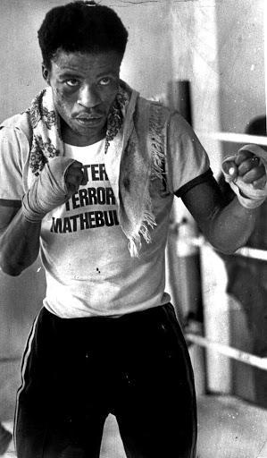
Peter “Terror” Mathebula dies

Peter “Terror” Mathebula dies

On 18 January 2020, Peter “Terror” Mathebula South Africa’s first black world champion boxer died. Mathebula was born on 3 July 1952, in Transvaal (now Gauteng). A flyweight division boxer, Mathebula made his professional boxing debut on 10 July 1971 against compatriot Sydwell Mhlongo in Rabosotho Hall, Tembisa, Transvaal. On 13 December 1980, Mathebula became South Africa’s first black world champion when he dethroned South Korea’s Tae-Shik Kim in Los Angeles, California, USA.

Cederberg Wilderness Area

The Cederberg Region is only two hours from Cape Town and yet the landscape is completely different. With much wilder, warmer with a raw, dramatic beauty. Clanwilliam and Citrusdal with its towering Mountains, brilliant purple and orange sunsets, laden with the scent of orange blossoms in the Spring. Lamberts Bay and Elands Bay; with their perfect waves for surfing, offer open-air Restaurants serving only the best of our seafood and have an abundance of bird life to be spotted.

Wupperthal and Elandskloof, both Missionary Villages situated within these magnificent Mountains. They both have a wealth of History. Enjoy the beauty of the Cederberg in your own way: walk in the Mountains with not another person in sight, enjoy bouldering and climbing at Rocklands; go and discover the beautiful bird life or get your surf on; swim in the clear Mountain rock pools or marvel at the delicate Bushman rock art. Southern African rock art has been dated to be as old as 28 000 Years, with the age of the Cederberg paintings ranging from 8 000 Years to 100 or 200 Years. The paintings most commonly depict animal scenes, and it is thought that particular animals such as eland, have important symbolic religious meanings. Paintings were made by the San as part of their Religion and can thus not be interpreted literally! Humans are also commonly depicted, often in procession, hunting or out gathering food. Other types of paintings show therianthropes (half-animal half-human figures) and entoptic- (occurring or originating inside the eye) shapes, probably of important religious meaning.

Rock art sites in the Cederberg Conservancy open to the public are: Stadsaal; Truitjieskraal; Southern Arch and Vark Kloof.  Or simply relax and enjoy the exhilarating peace of this unspoilt paradise. The Cederberg has an exceptional Botanical diversity, being part of the Cape Floral Kingdom of the Western Cape. This Are is among the twisted rock formations, farmers cultivate the World-famous healthy rooibos tea, found only in the Cederberg of South Africa!

Geolocation
-32° 21' 28.8", 18° 14' 34.8"
References
https://www.cederberg.com/ https://www.cederberg.co.za/environment/khoisan-rock-art http://www.cederbergmun.gov.za/

Katberg, Eastern Cape

About 30 kilometres from Hogsback and close on two hours from East London, the little town of Katberg lies in enviable countryside. Citrus orchards, green lucerne fields, clear rivers and soft green valleys with forested ravines - this part of the world is clearly beautiful. People here speak about going up the Katberg, although its grassy summits are really regarded as a section of the Winterberg Mountains. The Katberg pass, almost unfeasible in an ordinary car as the condition of the road is now really poor - rather like driving on a lawn as the road carries so little traffic that grass grows right across it - offers scenery to take your breath away at the top. Hiking in this part of the world is a way of life and the Katberg forest is the scene of several day walks lasting from one to four hours around the forest station and the Katberg Hotel. There are also the Katberg loop trail and the Katberg hiking trail, both of them fairly arduous walks. The nearby Thrift Dam is a must for fishing fanatics. The most easterly and largest of the trout fisheries in the area, it lies on the uppermost reaches of the Black-Kei River and is stocked with rainbow trout that average two kilograms a piece. But it is the incredible lack of restriction and feeling of expansiveness that come from a holiday in the mountains that makes Katberg such a wonderful place to stay. Katberg is about breathing in fresh mountain air and enjoying the solitude of being in nature in a part of the world that remains unspoilt and beautiful in its own right.
Geolocation
26° 40' 30", -32° 29' 27.6"
References
https://www.sa-venues.com/attractionsec/katberg.php

Robberg Nature Reserve

Robberg Nature Reserve, situated 8 km south of Plettenberg Bay on the Garden Route, is not only a nature reserve, but also a National Monument. Rocks from this region date back 120 million Years to the breakup of Gondwanaland and evidence of middle and later Stone Age inhibition has been found in a few of the caves along the Peninsula. Visitors can find out more at the Nelson Bay Cave Interpretive Centre. Some highlight features of a visit here include spotting the rare 'Blue Duiker', the Western Cape’s smallest antelope; walking alongside one of the seven climbing-falling dunes on the Cape Coastline; and viewing the highest navigational light on the South African Coastline, at the Cape Seal Lighthouse (146m above sea level). The Reserve also extends 1.8km offshore, providing protection to a range of vulnerable fish species. Visitors can expect inspiring Landscapes, exciting dolphin and whale sightings in season, and to be accompanied on their walks or hikes by a variety of bird species and the occasional seal. An overnight hut is available for those who want to spend more time on this beautiful Reserve.
Geolocation
-34° 6' 14.4", 23° 23' 34.8"
References
https://www.plett-tourism.co.za/activity/robberg-nature-reserve/ https://www.capenature.co.za/reserves/robberg-nature-reserve/
Further Reading
https://www.instagram.com/p/C4DRU_cNb4a/?igsh=MmtnNTF2em1lNWt1 http://www.capenature.co.za/wp-content/uploads/2013/08/Robberg-Nature-Reserve-Brochure.pdf https://www.capenature.co.za/reserves/robberg-nature-reserve/ https://www.sanbi.org/animal-of-the-week/blue-duiker/ https://www.getyourguide.com/garden-route-l32178/dolphin-whale-watching-tc49/?cmp=bing&ad_id=78340408337216&adgroup_id=1253443904777242&bid_match_type=bb&campaign_id=710117271&device=c&feed_item_id=&keyword=-l32178%2F&loc_interest_ms=136825&loc_physical_ms=137943&match_type=b&msclkid=dbd4ff0f84081b23508d9afd4dd50d5d&network=o&partner_id=CD951&target_id=dat-2330140017440120&utm_adgroup=lc%3D32178%3Agarden%20route%7Cfn%3Df1%7Cagt%3Ddsa&utm_campaign=dc%3D68%3Aza%7Clc%3D32178%3Agarden%20route%7Cct%3Dcore%7Cln%3D29%3Aen%7Ctc%3Dall&utm_keyword=-l32178%2F&utm_medium=paid_search&utm_query=dolphin%20and%20whale%20sightings%20in%20the%20garden%20route&utm_source=bing https://www.capenature.co.za/reserves/robberg-nature-reserve/