History Classroom

History in Images

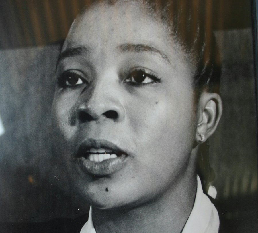
One of the organisers of the 1956 Women's March, Lilian Ngoyi
A young victim of the atrocities committed by Belgium in the Congo stands next to a missionary. 
Image Source:
www.wikimedia.org
Riot police play a game of soccer with youths in Nyanga on 27 August 1976. Photo by John Paisley
Image Source:
www.lib.uct.ac.za
A certificate of slavery for an infant named Sophie, dated 1827 Cape of Good Hope. 
Image Source:
www.theculturetrip.com
Riot police attempt to block the way of workers leaving a May Day meeting at Khotso House in Johannesburg in May 1985. 
Image Source:
www.digitalcollections.lib.uct.ac.za
A family sits outside the front door of their District Six home in Cape Town in the 1970s, prior to their forced removal. Photograph by Jansje Wissema. 
Image Source:
www.digitalcollections.lib.uct.ac.za

Seweweeks Poort, Swartberg

The Seweweeks Poort is probably the most beautiful 18 km stretch of gravel road anywhere in South Africa. With easy gradients, multiple river crossings, mind-boggling geology, camping and self catering accommodation all packed into an almost perfect micro-climate, this road is an absolute joy to drive or ride, as it twists and turns through every angle of the compass, as it follows the contorted bends of the River and falls entirely under the control of Cape Nature Conservation and more specifically the Swartberg and Towerkop Nature Reserves. It is also a certified UNESCO World Heritage Site. The Gamkapoort Dam, was built by the Dept. of Water Affairs in 1960 for farmers in the Gamka River Valley near Calitzdorp. Once the dam was completed, it effectively cut off road access via the R 407 to Prince Albert and a different routing had to be found. The Swartberg Mountains tower over the road and for the first time visitor it seems impossible that a road exists through this massive jumble of contorted rock formations. Passes normally exhibit small altitude variances, but the this one has a height difference of 479 m, which is more than many major Passes in South Africa. Due to its long length of 17,7 km one hardly feels the gradient changing and for cyclists, the Pass is a joy to ride from North to South. The Pass provides a considerable shortcut for travelers wanting to go to Ladismith or Calitzdorp from Laingsburg or Sutherland. The Route is designated officially as the R 323 but its official number is the P 0903. The surface is gravel throughout which is generally maintained in a good condition. The road does suffer frequent damage after heavy rain. In the Northern sector of the Pass, most of the River crossings are simple concreted drifts, but as the River gets bigger towards the Southern end, the crossings become more sophisticated as the drifts become fitted with underground pipes and later by actual small concrete Bridges. (None of these have guard rails, so make sure you drive conservatively!) Besides the exquisite Seweweeks Poort itself, you will also be able to enjoy the Rooinek Pass, Witnekke Pass and the Koueveld Pass on the way from Laingsburg before you reach the Pass - all of them are close to the Swartberg Nature Reserve or the Towerkop Nature Reserve. It is a beautiful drive (especially in Winter and Spring) with a vast variety of Mountain scenery to enjoy. There is an array of stories as to where the Poort got it's name from, most of which are folklore! The most likely version is that it is named after the Seven Weeks Fern (Polystichum Andiantiforum), which in Afrikaans is called the 'Seweweeksvaring', which grows all over the Poort in moist places and crevices. This is the officially accepted version. Other more fanciful interpretations are that the Pass was originally named after one of the Amalienstein Missionaries - Dr Zerwick and that the locals could not quite pronounce his name correctly and it changed from Zerwick to Zeweweek over time. Research has proven that no Dr. Zerwick ever served at Amalienstein,though! Another story is that it was said to take 7 weeks for the brandy smugglers to get their wares from Beaufort West to Ladismith via the Pass. Yet another insists that it took 7 weeks for the authorities to capture a cattle rustler who had disappeared into the Kloof. All of these stories conjure imagery of a bygone era and they all add to the magical allure of the Pass!


Geolocation
21° 22' 55.2", -33° 23' 56.4"
References
https://www.mountainpassessouthafrica.co.za/find-a-pass/western-cape/item/263-seweweekspoort.html
Further Reading
https://www.westerncape.gov.za/public-entity/capenature-0 https://www.westerncape.gov.za/your_gov/64

Inxuba Yethemba Local Municipality, Eastern Cape

The Inxuba Yethemba Local Municipality is a Category B Municipality situated in the Chris Hani District in the Eastern Cape Province. It is approximately 240 km North of Nelson Mandela Metropolitan Municipality. It is one of six Municipalities in the District, making up a third of its Geographical Area. Cradock consists of the Suburb of Cradock, and the Lingelihle and Michausdal Communities, whilst Middelburg has the Suburb of Middelburg, with the Kwanonzame Lusaka and Midros Communities. The two Urban centres of Cradock and Middelburg are fairly similar, with well-developed CBDs and fair infrastructure. (A lot still needs to be done in the former previously disadvantaged communities.) The Rural Areas of both Towns are mostly Commercial Farms, with small Settlements in the Rural Areas of Fish River Mortimer and Rosmead. The N 10 National Road, which is the vital economic link between Port Elizabeth and the North, runs through Cradock and skirts Middelburg.
Geolocation
26° 3', -32° 15'
References
https://municipalities.co.za/overview/1024/inxuba-yethemba-local-municipality

Hawaan Forest, Umhlanga

Across the M 4 the Forest rests on a 2 000 year-old sand dune. Sounds old enough but Hawaan, by contrast, stands sturdy on a sand Dune that is 18 000 years old. It’s mind-boggling to think that something that old still exists… Hawaan Forest, owned and managed by 'Tongaat Hulett', is 80 hectares of pristine Coastal Climax Forest. The ‘climax’ part of the description, we learn, means it has reached its full potential of growth. Despite sounding as though it has reached its zenith, the term ‘climax’, in fact, refers to its capacity to reproduce indefinitely, largely due to its providing its own shade. Hawaan is the also last of its kind. Which is why Jocelyn, as the forest’s custodian and member of the Botanical Society, is so very passionate that it remain unharmed, and that people come to understand how vulnerable it is. ‘That people dump alien invasive plants along the perimeter of the forest is the real issue,’ explains Jocelyn. ‘If the seeds of these plants germinate then the pristine quality of Hawaan is endangered, particularly as we have worked so hard to clear and maintain the forest.’ Hawaan is a dry-Forest, which means there is no natural water source. Not even rain really affects the Forest because of its density – the Forest is thick with creepers – various varieties and 48 different species, we learn as we begin to follow Jocelyn along sand paths she and a group of women clear on a regular basis. To add to the Forest’s value, there are 187 different species of trees in Hawaan alone, many of them Endemic to the Area. When you consider that the whole of Europe has but 67 different tree species, Hawaan begins to take on legendary proportions. Jocelyn is a font of knowledge. She regularly points out different trees and vines, like the endemic Natal coshwood that always grows in tandem with the equally endemic Natal hickory. Other trees have names that sound as though they belong in a story about faerie folk: wild asparagus, forest fever berry, forest olive, the dwaba berry, wild grape, and white stink wood. By now we’ve reached a clearing in the Forest that she explains is used during a bi-annual non-denominational blessing, of the Forest. A bench rests off to one side in memory of Alistair and Phoebe Carnegie, who up until recently tirelessly worked to maintain the forest until Jocelyn took over as custodian. We hear the call of the Knysna Lourie and later sight a big group of Crested Guinea Fowl. But they are so shy, and so obviously worried by our presence, that we do not manage to get terribly close. Double-barrel vines twist and turn and we have to manoeuvre ourselves through and around them in a parody of tunneling. Some of the vines are so thick they look more like ropes than vines. We reach a buffalo thorn tree, which Jocelyn explains is the granddaddy of trees in Hawaan. Many of the tribes in Africa are buried with a twig of Buffalo thorn; one thorn to indicate a past life, two thorns for a future life. This particular example, she thinks, is about 400 years old. It is unusual to see buffalo thorns as tall as they are in Hawaan where they function as canopy trees. Many of the trees in Durban's Ancient Forest have split trunks. This is a natural form of coppicing, when a tree produces multiple stems growing out of the main trunk. Often one of the stems is dead, and the tree, in a bid to regenerate, produces a new trunk. Jocelyn points out a couple of what she calls ‘natural gaps’ in the Forest. They look like simple clearings or openings in the Forest canopy and have no reason for being there. The Botanical Society, and the group of students from the local University busy studying the Forest whilst comparing it with other ancient afromontane forests on the Coast, are busy monitoring the gaps, but neither has an explanation. Ahead of us is a thorny elm (Chaetacme aristata) which has a classic example of coppicing from its base. Its naturally swollen bases of branches look exactly like knobkerries used by Zulu tribesmen as an attacking tool. But they also look almost impossible to remove, the wood is so hard. Birds love the thorny elm, and snakes use the bark to slough off their skins. By now we’ve walked through a lot of Forest and I can easily imagine getting lost (Jocelyn relates how, indeed, parties have found themselves walking in circles trying to find the path, which is easily covered with leaves). We have reached a part of the Forest where there are bigger spaces between the trees; the sea just visible between the predominantly white stink-wood trees. I realize how this undulating Forest and its beauty have grown on me. It is a pity there is no formal way for people to share the Forest’s beauty. Keeping it under lock and key, although understandable, does seem a shame. To visit the Hawaan Forest: Contact Jocelyn Sutherland on +27 (0)83 275-2216. Take along: A hat, binoculars, a sturdy pair of walking shoes and a willingness to sit awhile before seeing any birds. Other animals in the forest: bushbuck, bush-pig, mongoose, tiny duiker, scrub hair, African rock python, dwarf chameleon, coast purple tip butterfly (endemic to KZN).
Geolocation
31° 5' 24", -29° 42' 43.2"
References
https://thdev.co.za/2017/11/new-sibaya-coastal-precinct-conservation-trust-protect-enhance-natural-assets/
Further Reading
https://www.iol.co.za/business-report/companies/ethekwini-digs-in-its-heels-over-umlanga-land-774582 https://thdev.co.za/2017/11/new-sibaya-coastal-precinct-conservation-trust-protect-enhance-natural-assets/